Showing posts with label Nordic Walking. Show all posts

Thursday, 2 August 2012

Lake Pupuke - Pupukemoana

The PumpHouse Theatre
I arrived early on Sunday at the PumpHouse theatre car park opposite Lake Pupuke, inTakapuna. It was damp and dreary and I started to wonder if I was the only Nordic Walker daft enough to brave the elements, however after a short wait, North Shore Nordic Walkers began to arrive.
The Lake was grey and looked most uninviting but didn’t seem to deter the black swans that glided through the water, curious to see us arriving and starting out with our poles.

View Of The Lake From The Car Park
It's a freshwater lake, shaped like a heart and is actually two linked volcanic craters that are situated between Takapuna and Milford on the North Shore. Sadly, it’s not possible to walk completely around the lake as houses have been built right up to the water in some places; most of the walk  has to be navigated using road and park walkways.

Entrance To Henderson Park
Maori legend has it that the lake was formed after a Tupua couple (spirit or demon), descendants of the Firegods, were disrespectable to Mahuika the firegodess, so she had their home destroyed by Mataoho,the god of earthquakes.  Lake Pupuke was the result of Mahuika’s wrath and Rangitoto was apparently raised from the sea for their exile.

Black Swans On The Lake
The full Maori name for the lake is Pupukemoana, which means “overflowing lake”.  This area is of great significance for Maori history.  There are documented ancient lava caves (Tapua; sacred) on the edge of the lake where Maori would bring sacred bones to rest, these were discovered by early European settlers. There is also evidence that there was a Papakaiinga (settlement) near the lake.

In 1894 a pump house was built by the lake which pumped fresh water to the local area. It was replaced in 1906 and as demand increased the water level of the lake fell and the quality quickly deteriorated. Use of the lake for freshwater stopped in 1944 and supplies were sourced from the Waitakere Ranges. The second pump house became a protected building in 1983 and is now used as a theatre.

Nordic Walking Downhill To The Lake
Our group walked up the hill, turned left out of the car park into Manurere Avenue, then taking another left we continued along Killarney Street and onto Hurstmere Road.

We poled along until we came to the entrance for Henderson Park situated between the houses on the left  and followed the path along the lake edge.  It’s a beautiful walk, slightly soggy underfoot but gorgeous views of the lake and waterfowl.  Keeping the lake to our left we continued with our walk to Sylvan Park, where we came across a few teams of rowers practising.  This area is very popular for water sports and with school kids that take part in the Waterwise programme.  A little further along along we stopped at the Milford Waterwise building to allow some of our walkers to catch up.

Early Morning Boat Races On The Lake
Turning right we passed through Milford school, it looked like there was a swimming coach giving lessons at the school pool it was pretty chilly I must say I didn’t envy them at all! We turned left outside the school entrance and walked along Shakespeare Road to North Shore Hospital.  I hadn’t been to the hospital for a while and I was surprised to see that they had finished the new car park there.

Kids Get The Opportunity To Sail Optimist During Waterwise Classes
We continued along turning into Taharoto Road then took a left  turn at the end into Rangitira Ave and right into Pupuke Road.  At the top of Pupuke Road we turned left back into Killarney Street then back into the car park by the Pumphouse.  The car park was now very busy, a few more walkers had arrived and a diving group with all their paraphernalia spilled over the grassy bank alongside the lake.

New landscaped Garden At North Shore Hospital
We arrived in the nick of time at the Rendez-Vouse cafe next to the theatre as it began to rain. This is a small cafe, warm, with pleasant surroundings overlooking the lake - I bet it looks awesome in summer.  I had lemon and ginger tea!

Information and sources:
http://www.arc.govt.nz/environment/volcanoes-of-auckland/lake-pupuke.cfm

Tuesday, 5 June 2012

Shepherds Park – Oruamo Creek

A few peeps were surprised that I had organised a walk on Sunday as it was the Queen’s Birthday weekend.  My philosophy is that I’m sure that the Queen won’t mind and as her royal subjects we owe it to her to keep fit and well.

Shepherds Park, Beach Haven
I chose Shepherds Park as June Stevenson and I have worked there with Green Prescription patients, we’ve only used the footpath and park and when I found that there was a walk around the estuary I was keen to take a look.

Beach Haven is located North West of Auckland city, the first European settlers to this area arrived in the 1860s and until the early 1920s the area was primarily rural consisting mainly of farms growing strawberries and holiday homes (baches).  The area was subdivided for housing later in 1923 and during the construction in 1959 of the Auckland Harbour Bridge the housing development in the area was sufficiently completed to make it into a largely urban populated area.

Making our way to the Bush Walk
Shepherds Park is named after the family who lived there on a farm, originally the area was market gardens before it was developed into a park for community use.  The park offers many amenities including rugby, soccer and tennis; it also features an outdoors fitness circuit for anyone to use.
The headland that is adjacent to the park has been restored to a beautiful bush environment. It’s situated on Hellyer’s Creek and still contains middens from previous Maori occupation. Centuries later Thomas Hellyer opened a kauri mill business in 1840 that supplied timber to Auckland city.

Outstanding views of Hellyers or Oruamo Creek
North Shore Nordic Walkers met at 8.00 am at the park via the Melba Street entrance and parked outside the football (soccer) club. We were joined by June and Paul Stevenson from Nordic Kiwi who were also keen to try the walk.
We started our walk by taking the path on the left past the back of the soccer club, turning right at the Oruama Landing sign we made our way through the bush and onto the track. We followed the track by the coastline though the bush alongside the houses that back onto the water.  

Some of the steps are steep and can be slippery
I’d advise anyone trying this track to take extra care when it’s wet as it is full of tree roots and holes. It is quite boggy in parts although some of the track is boardwalk and there are steps to climb to take in the views of the estuary and the upper harbour, with a backdrop formed by the steep slopes of Greenhithe.

Beautiful tree canopies along the walk and some branches are at head height!
We stopped to look at the views at Hellyers Creek (Maori name is Oruamo which means “for all”) before continuing along the coastal track.  The views are truly outstanding along the estuary, we passed many little wharves some of which looked to be in very precarious positions. The area is marsh wetland and teaming with birds. The plants and trees are magnificent along here, with huge rimu, kauri gum trees and many of New Zealand’s native trees have been replanted by volunteers and the team at the Kaipatiki planting project.

Beautiful views along the estuary track
We proceeded along the track before exiting at Beach Haven Road, turning right we then continued right into Lancaster before taking the left turn back into Melba Street and onto the car park.

Boardwalk view
I think everyone was surprised and delighted at such a beautiful walk that is tucked away on the other side of the park. It’s definitely worth about an hours trip out to walk the area.
One of the small wharves along the way
After a short deliberation we took the cars into the small centre of Beach Haven and walked across to Cafe Au Bon Coin Patisserie, which is on the corner of Rangatira Road. It’s a small establishment but has the friendliest staff with excellent service and I can recommend poached eggs on toast, ils étaient très bons. ; )
Information and Sources:

Wednesday, 23 May 2012

World Nordic Walking Day 2012

New Zealand


This is the third year of the World Nordic Walking Day event, and New Zealand was the first country to commence the celebrations at the Sir Peter Blake Marine Educational and Recreational Centre at Long Bay, Auckland on the North Shore and hosted by Paul and June Stevenson our INWA representatives. The centre is ideally located with fabulous views of Long Bay beach and cliffs, and a great venue for our event.

The Sir Peter Blake Marine Education &Recreation Centre
Despite the cold and wet weather the previous day we had a great turn out and the weather improved as we met at 8.30 am and separated into our groups for the two walks starting at the beach. There was a 45 minutes walk through the park and back and a 90 minute walk organised to go up the cliff past Granny’s Bay.

Taking Poles to Long Bay Beach
Long Bay beach is a kilometre long and to start the celebrations of our unique exercise of Nordic Walking we warmed up with some exercise on the beach then walked to the North end to walk across the park, along the grass and towards the Vaughan Homestead. 

Warm up on the Beach
The homestead is over 100 years old, made of New Zealand Kauri and Puriri native wood. It stands overlooking the beach at Long Bay with magnificent views of the park. We lingered a while to look at the view before taking the nature trial through the bush and separating into our groups. 

Vaughan House Greensleeves - Caught you Sheila
Our group led by Paul and myself walked through the cattle gates across the trail and onto the cliff top. The views are simply magnificent, it’s quite slippery along the rest of the cliff track here and we picked our way carefully through the mud and wet grass to a great viewpoint - someone was surprised that they could see the lighthouse at Tiritiri Matangi Island.

We returned to the track via the Nature Trail and through the park, taking a toilet break along the way and then back down the beach to MERC at the South end.

Top of the Cliff before Pohutukawa Bay
At the centre we had a quiz, speeches and acknowledgements for Nordic Walkers that had achieved their personal goals by entering events.
Paul Stevenson gives the Message from INWA President Aki Karihtala
All of the speakers were Nordic Walkers and most had very personal and interesting experiences to share with us.  It was a great fun morning and we are lucky to have some strong Nordic Walking groups across Auckland; we did have Nordic Walkers visit us from Rotorua too.  It was a great opportunity to catch up with some of the other groups and Walking Group Leaders and exchange walking ideas and walk plans.

Bronze bust of Sir Peter Blake
The morning went so quickly I felt like I didn’t get the chance to speak to everyone that I would have liked to, but it did give me the opportunity to meet some of our new Nordic Walkers. June mentioned one of our instructors Sandrine Smith is leading a team for the Arthritis NZ marathon and I will also be taking part and are looking for more participants.  If you want to know more about the event or sponsor our team, The Nifty Nordic Walkers here’s our details: http://ow.ly/b5man. Thanks!


Wednesday, 16 May 2012

Orewa - Alice Eaves Reserve

Before I met with the intrepid North Shore Nordic Walkers on Mothering Sunday, I was presented at 6.00 am in the morning amid lots of clattering in the kitchen, a beautifully made cooked breakfast consisting of two hard boiled eggs, bacon, beans, two crumpets and a toasted teacake by my two beautiful children.  Needless to say by the time I met the group at Orewa Surf club at 7.30 am I was fit to burst!

Orewa Beach and Surf Club
Orewa is a small town North East of Auckland city centre, the beach is ideal for Nordic Walking. It is 3 kilometres of long sandy beach situated on the Hibiscus coast, home to surfers, kayakers, kite surfing, wind surfing and swimming.  You can also catch the Orewa Surf Club life guard training and events down on the beach on a Sunday. The clubhouse was originally first built in 1960 although the club history dates it back to the 50’s. It was added to in the 70’s but  in 1990 the clubhouse was finally finished and is now located in pole position adjacent to the beach at the South end.


Road to Alice Eaves Bush
The morning was cold but sunny and ideal Nordic Walking weather, so we wrapped up and ventured forth.

We walked to the North end of the beach and crossed over the Hibiscus Coast Highway to The Old North Road and into the entrance for Alice Eaves Reserve.

Kauri Tree over 300 years old
There is a massive Kauri in this reserve over 300 years old and the area is brimming with native trees like Puriri, Rimu,Totara and Nikau, you definately get the sense of history walking amongst some of these ancient trees.

There is a Pa not far from the Hillcrest boundary; apparently it has a few middens that indicate it was previously used as a living area by Maori tribes people in the area and was lived in until around 1827. The land was taken over by European settlers and was eventually purchased by Mr & Mrs Eaves in 1919. When Alice Eaves died in 1955 she bequeathed the land back to the nation.

Nukumea Stream Walkway
The reserve is maintained by the Lions club, they have signage on the gates and signposts at some of the trees.

We walked through the Reserve on the lower track which takes you along a wooden walkway that runs adjacent to the Nukumea Stream and the Kensington Park development.
The Blue Footprints for the Millenium Footpath
The track does go on further but there is no walkway and can be very slippery underfoot, we continued along until we came to the point where the track became unsafe.  We then headed back to the stream and the crossing at Kensington Park. There is a higher track that leads onto the Pa area but we'll leave that for another day.
We then walked through the new housing area and back onto the millennium path at Puriri Ave continuing along the road and back across the highway onto the beach.

The Clock Tower on Puriri Ave
The group unzipped and de-coated feeling very warm, some of us made it over to the King’s Plant Barn for coffee.  I really couldn’t face another breakfast so I ordered a berry smoothie again.

Information & Sources:

http://www.orewasurfclub.co.nz/history.html
http://www.rodney.govt.nz/DistrictTownPlanning/plans/ReserveManagement/Documents/Alice_Eaves/AliceEaves_Amended_Plan_March08.pd

Wednesday, 9 May 2012

Kell Park - Kaipatiki

Sunday brought the North Shore Nordic Walkers cold autumnal weather, it was a grey and cloudy start, but at the end of our walk the sun had cracked through. We met in the library car park at Kell Park, Albany. This park is becoming quite a favourite walk, it’s fairly flat and runs adjacent to Lucas Creek. I’m not sure if I have mentioned this before but Albany is actually from the Gaelic name Alba, which is the Gaelic name for Scotland.

The Landing used in the past as a terminus for boats travelling to and from Auckland
I did organise a trip to Albany Trig, it’s actually across the road from Kell Park, but the pathway is being repaired at the moment and it’s very slippery underfoot. If you do visit the Trig, take somebody with you as it’s very steep in places and you will have to cross the creek; there is no bridge but it is do-able just take your time and stick to the path. If you make it across there is a lovely waterfall with a picnic table and seats situated just opposite the fall.

To start the walk we turned left and down the steps, turning left again at the bottom of the steps and over the bridge. Walking through the park and past the houses on the left then continuing along the path and onto the Landing area.
Lucas Creek
In the past there was a small Pa situated North of Lucas Creek where Maori would hunt for crayfish and eel, the land around this area was known as Kaipatiki which means 'to eat flounder', or the 'feeding ground of the flounder'.

Many wharves were built around the Landing as water travel was the most common way to transport goods, to travel to and from Auckland, and to travel around the North Shore. The Landing certainly became the most used terminus but was demolished in the 1930’s and has over the years been developed as a residential area.
Massey, Albany Campus
Taking a a right turn once we emerged from The Landing we continued following the footpath along the Albany Highway past Albany Campus, Massey University on the left.
We walked down Bass Road and through the streets to Kinleith Way, had a joke about dropping in for a cuppa at Margaret’s house but pushed on, eventually walking through a small entrance between the houses, following the path alongside the Creek.

The bush and trees along this pathway are full of birds, and it’s interesting to note that many of the  properties overlooking the Creek are laden at this time of year with fruit. I had never seen citrus fruit growing in gardens before I moved to NZ.  Even in Greece and other European countries the fruits I have seen are generally grown in orchards.
The Creek Surrounded by Native Trees and Bush
We crossed the Creek at a small bridge taking the path back onto Albany Highway and  walked back towards The Landing. Small platforms or jetties have been erected along the waterside presumably for fishing and there quite a few ducks out on the water.
The Massey Campus car park was deserted - a strong contrast to what it normally looks like during the week.  Built over 15 years ago the Campus is a huge establishment with a Spanish architectural theme, it’s one of the most modern Universities in New Zealand.

Canon at the top of the Flying Fox
We ambled along the pathway and back into Kell Park where we stopped for while and watched Pam E chicken out of riding the Flying Fox, but I spotted a white duck out on the water so we headed over to take a look. Its a great place to take the kids with a huge slide and cannon for them to explore.

Wooden Sculpture at Albany
We finally made our way across the grass to the children’s play area and had chat by the  bronze sculpture in Albany village square but somehow our cafe arrangements got confused and Cindy and David wandered down the road whilst the rest of us had a muffin and a beverage at the Opium Cafe.  
The lifesize rooster and chair was created by a local artist Joanne Sullivan-Gessler in 2004. It appears that the rooster has attracted some attention from thieves in the past and the life sized sculpture has had a couple of attempted thefts. It must be really heavy and I can't imagine that it would be easy to remove without the use of some kind of equipment.

'
'Balance' Rooster Sculpture at Albany Village Square
Anyway I had  a berry smoothie and someone asked what was in it. Apparently it is made of berry concentrate and vanilla powder mixed with ice. Think I may stick with Lemon & Ginger tea on our next visit.

It’s worth mentioning at the end of this week’s blog that I did actually go out on Saturday night to a party, and was rather jaded on Sunday morning. After our walk and on returning home I found I had spent the whole morning walking with my pants on inside out and nobody told me!  Seems that wearing your clothes inside out is supposed to be very lucky, not sure who for though!

Next Sunday I will have the said walking pants back on the right way around!
Information & Sources

http://www.harboursport.co.nz/site/harsport/files/ACOM/albanyandlucascreek.pdf

Tuesday, 24 April 2012

Hobsonville Point

Last week we had a local walk and I didn’t really have much to say about it, but this Sunday North Shore Nordic Walkers met at Hobsonville in the morning; we parked opposite the Catalina Cafe and it was quite an adventure. I copied a map from the Internet to try a walk around Hobsonville Point. Unfortunately some of the walk had been interrupted by earthworks for new housing and school development and a good portion of it wasn’t easy to access.  The place was really busy though, they have a traditional farmers market on a Sunday at 9.00 am and the place was already bustling as we passed through.

The Catalina Cafe
We crossed over the road at the Corner of Buckley Ave and Hastings Crescent and walked around the back of Catalina Cafe. We poled past the community plant network garden, down past the children’s playground and past many of the old service buildings.   

The Quaint Church or Pump House
Hobsonville Point was previously the Royal New Zealand Air Force airfield, set aside for development at the start of the millennium and is now emerging as a new semi rural suburb of Auckland, located on the North Western shore of Waitamata Harbour and named after the first governor of New Zealand.

Signposts around the Coastal Walk Path
Originally the area was used for farming, what I found interesting and a few of our walkers commented on, was that the earth that had been dug up by the bulldozers was mainly clay.  Apparently there were clay and brickworks in the area and most of the pipe work in Auckland would have been made there.
Some of our Nordic Walkers at the Landing
In the 1920’s the Royal New Zealand Air Force built the airbase which later joined up with Whenuapai airfield. Later in the 1930’s the air strip was evidently too short and the area was used as a repair and equipment utility.  Eventually in early 2000  the RNZAF relocated most of its logistics and operations elsewhere.
Walking through the old air base was really kind of eery, we all had that feeling that we shouldn’t be there, there were lots of signs stating that the area was strictly for Defence personnel only.

We made our away across the tarmac path and down to the Landing, this area was used by the old seaplanes, it’s a small concreted area that faces the sea, this will become the new Hobsonville wharf and ferry terminal.

View from the Landing
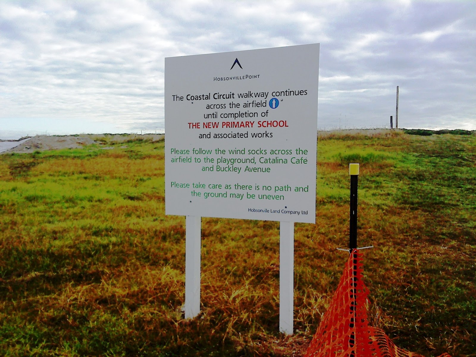
Eventually we came across signposts that lead us onto Bomb Point, it looked like there was a path in the grass and another walk.  We didn’t venture down the path but continued to the airfield where a sign told us to look out for the wind socks. Well with no wind socks in view we picked our way across the building site and walked across to where the new primary school would eventually be built.

Sign for Bomb Point which wasn't half as exciting as we expected
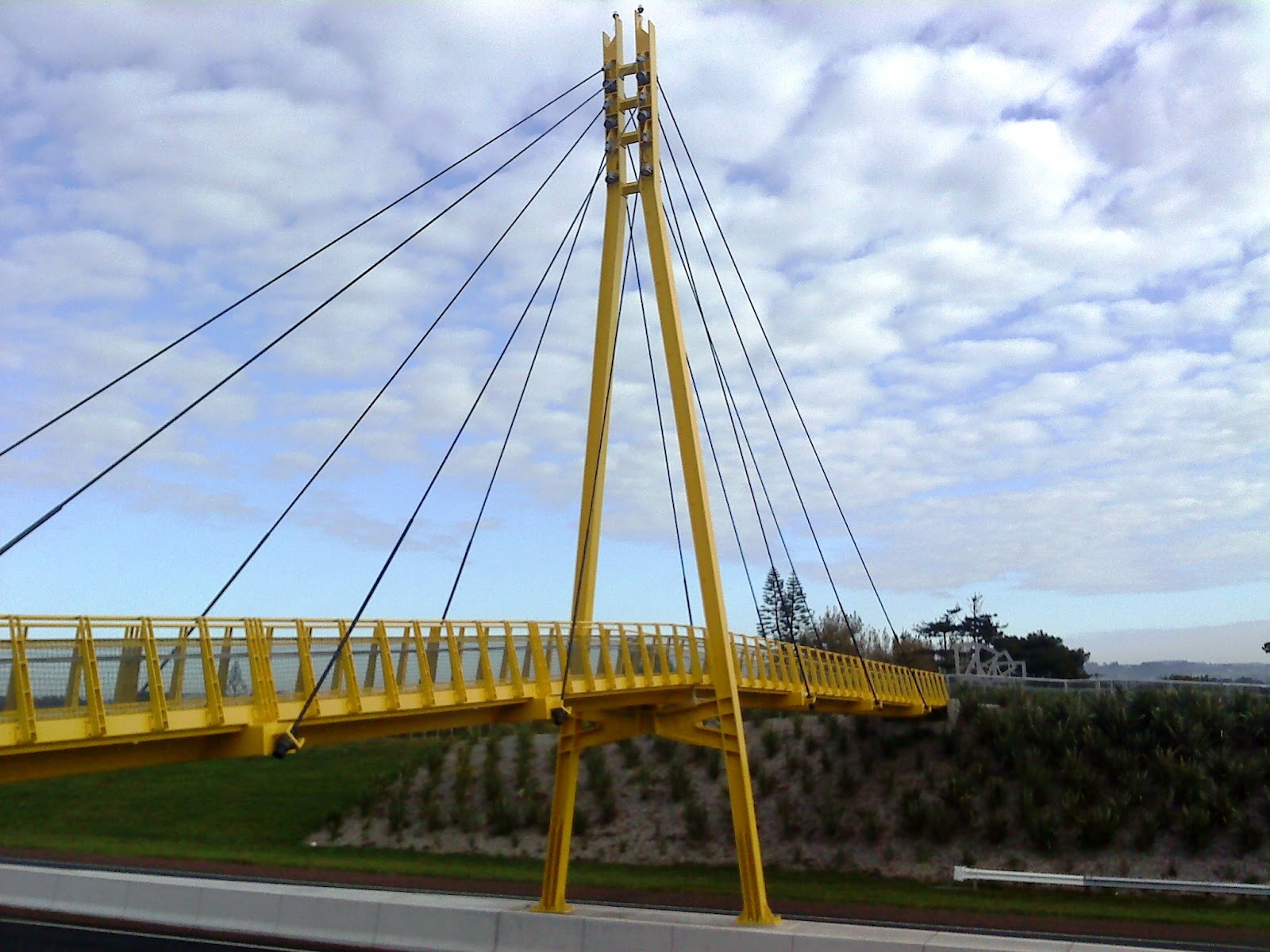
It was at this point when we came across a couple of ladies we saw earlier on the car park outside the Catalina cafe. I asked about any further walks and they pointed us in the direction of the yellow bridge so away we tramped, passing a pump station that we thought at first was a small church. We crossed over the road and made our way across the Memorial Park and onto Clarks Lane Footbridge.

Not a single windsock in sight!
The bridge is indeed canary yellow and is tiled at the edges with beautiful details, each tile along the end had some cycle or truck tread artwork being the creation of Matt and Kate McLean. They have been put together most decoratively and add a lovely touch to what could have been a boring path across a very busy highway.

From the bridge you can see what would have been some of the homes used by the pilots whilst working at Whenuapai airfield.  Mary pointed out some of the traditional houses and from where we stood we could also take a good view of the Sinton Windows Sculpture which was apparently created using recovered materials.
Clark Lane Footbridge
We were now ready for a coffee so we headed back past the park towards the cafe, however as usual we were distracted by the new housing development and took a slight detour to have a nosey at the new homes. 
Once satisfied that we weren't missing anything we ventured back past a lovely kiddies playground and onto the Catalina Cafe.

Matt and Kate McLean Tiles
The cafe was doing a roaring trade with hungry shoppers and walkers, however the queuing was short and service was fast, and I had two poached eggs on toast with lemon and ginger tea!  Some of the group went off to see the farmers market and the remainder made our way back to the car park.

Sinton Windows Sculpture
I think we’ll be returning to Hobsonville as it’ll be interesting to see the finished result - I might even go back and explore some of the other paths.

Information and Sources:
http://www.arc.govt.nz/albany/fms/main/Documents/Council/Consents/Notified%20applications/HobsonvilleLandco/Appendix%2010-21/Appendix%2010%20-%20Archaeological%20Assessment.pdf


Tuesday, 13 March 2012

Te Ara Tahuna Estuary


Estuary Cycleway and Walkway
Sunday was a wet day and I debated as to whether or not the walk should be cancelled.  I had arranged to meet some of the North Shore Nordic Walkers locally and others at the i-site at Orewa. Very often the weather can be atrocious in Auckland overnight then in the morning it can clear, at 6.30 am it was still bouncing down and rather cold.  I decided to carry on and the weather was fine, although still damp and colder than recent but the rain held as we walked around the estuary.

We started the estuary walk from the i-site car park and worked our way inland along the path, it’s a great walkway shared with cyclists and dog walkers.  The path is skirted by houses, some of which are big with spectacular gardens and views overlooking the water.  The concrete path is divided into a cyclist section and a walkway for pedestrians and cheerily shared by all.  We often stop and talk to people on our walk around as  the path is easily negotiated and reasonably flat, it’s also used for many walking and running events.  After a circuit of the estuary the path leads under the road bridge to the sea side where you can carry on past the camping grounds and walk down to the Surf Club and beach.  Today we walked along the estuary only and we had a new walker join us who already knew one of our regular walkers and she slotted in quite easily.

Garden at Orewa Estuary

We poled our way around the far side of the estuary past one of our favourite houses where the owner obviously takes great pride in their garden, it’s extremely ornate with lots of ornaments and little features dotted around the open garden.  We walked across the bridge, the native flax and lillies are starting to fade now but still dominate the water's edge.  We walked past the new housing complex, continuing along the path past Silverdale PrimarySchool and onto the bridge just outside Kingsway College. A little further along this path we bumped into June and Paul Stevenson taking the ‘Nordic Edge” class along the estuary.  It’s a great location for training, parking is easy and simple to measure your time and distance; if you get a chance to take one of the training classes I do recommend them.

Cycleway and Walkway
We continued along on the Southern side of the estuary past the new houses to the bridge and up onto the road bridge where we watched the tide coming in for a while as it came in really quickly.

The third bridge here was built in 1999, on the site of the first original wooden bridge that was built around 1881.  The second bridge was cleverly designed some fifty years later, there were no roads as such and water transport was used extensively which was a problem at Orewa river mouth.  The engineers however designed a turntable which allowed boats with masts to pass through.  Then as time progressed and road transport increased, the bridge became unsafe, a sharp turn caused many accidents off the road onto the bridge, so the larger bridge that is here today was developed that removed some of the dangerous curve out of the road. We walked back to the i-site car park, altogether this walk takes about an hour and a half and is roughly around 7.5 km; an excellent way to blow the cobwebs away on a Sunday morning!

Lillies along the Estuary
As I packed away my poles I noticed a lady unpacking her poles, they weren’t Nordic poles so I asked her if she had been walking long. In fact she hadn’t as she suffered a broken ankle in December and was still struggling but had read about Nordic Walking and decided to have a go to see if it helped with her recovery. Not one to miss an opportunity I instant whipped out a card and invited her to walk with us sometime and to take a class.  It’s amazing how many people actually buy tramping poles, I hope she was OK they looked way too tall and heavy for her!

Bank of the Estuary
We decided to try the cafe in the Estuary Art Centre, it was a bit slow as they were only able to make one coffee at a time and that meant we all drank at different times, but I did have the smoked salmon bagel which was rather tasty and I didn’t have to wait long at all.  We didn't have the chance to take a look around the exhibition, I was told that the centre was originally a Kentucky Fried Chicken emporium.  It certainly was a great venue for an art gallery, set on two floors with the upper floor immediately accessible by the entrance and the cafe occupying the space by the entrance.

We will have to have an explore of the gallery sometime!