Showing posts with label Pole Walking. Show all posts

Friday, 11 April 2014

Sanders Reserve - The Faraway Tree


Pam F, one of our Nordic Walkers asked me to accompany her to a place called Sanders Reserve, she had recently taken a Women's Outdoor Pursuits course and did some of her bush survival skills here. She was so taken by this lovely location that she felt she had to show me the area,  I was pleasantly surprised, this is a gorgeous place and a fantastic area to visit for a family or a group outing.


The 'Faraway Tree" - Phil Bonham
Sanders Reserve is about 10 minutes from Albany, it's situated South of Paremoremo and located by the Upper Waitemata Harbour estuary; it's a splendid location, providing areas for dog walking and horse riding. It has a small walking track, a fabulous playground for children and heaps of mountain bike trails with breathtaking views.

Pam took me to see this tree (above) which is along the walking track by an area called Library Point. This is a Macrocarpa (Monterey Cypress) tree and was crafted by Phil Bonham, an Auckland artist and sculptor.

There a wonderful Vimeo clip of Phil talking about his work on the 'Faraway Tree' sculpture, it's a lovely short film that explains where some of his inspiration came from for the figures and animals that are featured in his work.

Take a look: http://vimeo.com/73850678

More information:

http://www.thebigidea.co.nz/work/resumes/133024-phil-bonham
https://www.facebook.com/media/set/?set=a.599621883423361.1073741838.301561623229390&type=3
http://en.wikipedia.org/wiki/Paremoremo

http://www.wops.co.nz/

Thursday, 19 July 2012

Botanic Gardens - Totara Park Trail

Botanic Gardens, Auckland
The weather was pretty bad on Sunday morning and only a few of us took our poles and met up with some of Jenny’s group, the Acacia Cove Nordic Walkers at the Botanic Gardens, Manurewa.  The gardens are situated just alongside the Southern (SH1) motorway, it’s a bit of a trek from the North Shore but the Gardens are beautiful; not so much this time of year but four of us from North Shore Nordic Walkers turned up prepared to battle with the elements for a Nordic Walk around the Totara Park Trail.

Donning poles and stout waterproofs our small but enthusiastic group were lead by Ann though the Botanic Gardens and onto the path for the Totara Park Trail.

Nordic Walking Through The Botanic Gardens
Ann was very knowledgeable and chatted to us along the way about the trail and the surrounding area.  One of our walkers Mary, a retired school teacher, told us that there was a school camp facility here. Unfortunately the camp has long since gone, but the bush here is simply outstanding and it's easy to see why it was such a popular spot for a school camp.

Te Araroa - The Long Pathway
Originally the land was purchased by Mr Gillies in 1925 from the Manurewa Land Company, it was in a derelict state when he acquired the land and it was cleared to build a homestead.  The homestead was sold twice before being bought by the Council in 1966 after the previous owner had bequeathed that the homestead should stay and the bush remain in the property of the public.

Statue Outside The Visitor Information Centre

The park is typical of New Zealand bush, with native trees and plants in abundance and teaming with wild birds. The park is well signposted with information at various points about some of the tree and plants.

The track was in excellent condition, wide in parts, although there are a number of steep steps and a few inclines. It wasn’t long before we were at the trail for the Puhinui Stream Track some of which Ann said is bridle path, although we were assured that riders weren’t really encountered that frequently.  We followed the track for some time enduring the wet weather, chatting along the way; to be honest I hate wearing my raincoat, I can’t hear a darn thing so some of the information Ann was giving us was slightly lost so I hurried along to try and get as near as I could to listen.

Lookout Point - Sadly Not Much to See!
We eventually popped out along a road before continuing our track, stopping briefly under a tree before making our way over to the lookout point, Eugenia Rise.  Unfortunately because the day was wet and cloudy we couldn't see much, we could just make out Rangitoto and on turning around we could just see the faded outline of the Sky tower, both of which are always great landmarks to look out for.

We decided to head back to the Botanic Gardens for a coffee to dry off.

Some Of Our Very Wet Nordic Walkers
On the way back into the Gardens Ann pointed out the Te Araroa walkway, this  is a 3000-km trail  from Cape Reinga which is the northern tip of New Zealand to Bluff in the South and it officially opened in December 2011.  The trail one of the longest in the world, passes through bush, along coastline, through farmland and it even crosses through cities; it took ten years to get to the stage it is today and it was done with the help of hundreds of volunteers.

Boatanical Gardens?
The path alongside the Puhinui Stream was recently opened, it’s a significant section of the Te Araroa walkway and I think I read it was 12 km - it's already a very popular walk from the suburbs on the west through to the Gardens and Totara Park on the east.

We made our way back through the garden to the cars for a quick change of clothes and had a chat in Cafe Miko which is a lovely cafe, with beautiful views overlooking the gardens.

Sculpture At The Front Of The Visitor Entrance
My poached eggs and tea were very yummy, just the thing after a cold wet walk.  It's always a pleasure to catch up with our fellow Nordic Walkers and despite the wet weather this lovely walk was worth the wet tramp.
Information & Sources:

http://www.manukau.govt.nz/EN/Yourcommunity/ParksWalksBeaches/FindAPark/Pages/TotaraPark.aspx

http://www.teararoa.org.nz/auckland/puhinui-stream-track/

Wednesday, 23 May 2012

World Nordic Walking Day 2012

New Zealand


This is the third year of the World Nordic Walking Day event, and New Zealand was the first country to commence the celebrations at the Sir Peter Blake Marine Educational and Recreational Centre at Long Bay, Auckland on the North Shore and hosted by Paul and June Stevenson our INWA representatives. The centre is ideally located with fabulous views of Long Bay beach and cliffs, and a great venue for our event.

The Sir Peter Blake Marine Education &Recreation Centre
Despite the cold and wet weather the previous day we had a great turn out and the weather improved as we met at 8.30 am and separated into our groups for the two walks starting at the beach. There was a 45 minutes walk through the park and back and a 90 minute walk organised to go up the cliff past Granny’s Bay.

Taking Poles to Long Bay Beach
Long Bay beach is a kilometre long and to start the celebrations of our unique exercise of Nordic Walking we warmed up with some exercise on the beach then walked to the North end to walk across the park, along the grass and towards the Vaughan Homestead. 

Warm up on the Beach
The homestead is over 100 years old, made of New Zealand Kauri and Puriri native wood. It stands overlooking the beach at Long Bay with magnificent views of the park. We lingered a while to look at the view before taking the nature trial through the bush and separating into our groups. 

Vaughan House Greensleeves - Caught you Sheila
Our group led by Paul and myself walked through the cattle gates across the trail and onto the cliff top. The views are simply magnificent, it’s quite slippery along the rest of the cliff track here and we picked our way carefully through the mud and wet grass to a great viewpoint - someone was surprised that they could see the lighthouse at Tiritiri Matangi Island.

We returned to the track via the Nature Trail and through the park, taking a toilet break along the way and then back down the beach to MERC at the South end.

Top of the Cliff before Pohutukawa Bay
At the centre we had a quiz, speeches and acknowledgements for Nordic Walkers that had achieved their personal goals by entering events.
Paul Stevenson gives the Message from INWA President Aki Karihtala
All of the speakers were Nordic Walkers and most had very personal and interesting experiences to share with us.  It was a great fun morning and we are lucky to have some strong Nordic Walking groups across Auckland; we did have Nordic Walkers visit us from Rotorua too.  It was a great opportunity to catch up with some of the other groups and Walking Group Leaders and exchange walking ideas and walk plans.

Bronze bust of Sir Peter Blake
The morning went so quickly I felt like I didn’t get the chance to speak to everyone that I would have liked to, but it did give me the opportunity to meet some of our new Nordic Walkers. June mentioned one of our instructors Sandrine Smith is leading a team for the Arthritis NZ marathon and I will also be taking part and are looking for more participants.  If you want to know more about the event or sponsor our team, The Nifty Nordic Walkers here’s our details: http://ow.ly/b5man. Thanks!


Wednesday, 9 May 2012

Kell Park - Kaipatiki

Sunday brought the North Shore Nordic Walkers cold autumnal weather, it was a grey and cloudy start, but at the end of our walk the sun had cracked through. We met in the library car park at Kell Park, Albany. This park is becoming quite a favourite walk, it’s fairly flat and runs adjacent to Lucas Creek. I’m not sure if I have mentioned this before but Albany is actually from the Gaelic name Alba, which is the Gaelic name for Scotland.

The Landing used in the past as a terminus for boats travelling to and from Auckland
I did organise a trip to Albany Trig, it’s actually across the road from Kell Park, but the pathway is being repaired at the moment and it’s very slippery underfoot. If you do visit the Trig, take somebody with you as it’s very steep in places and you will have to cross the creek; there is no bridge but it is do-able just take your time and stick to the path. If you make it across there is a lovely waterfall with a picnic table and seats situated just opposite the fall.

To start the walk we turned left and down the steps, turning left again at the bottom of the steps and over the bridge. Walking through the park and past the houses on the left then continuing along the path and onto the Landing area.
Lucas Creek
In the past there was a small Pa situated North of Lucas Creek where Maori would hunt for crayfish and eel, the land around this area was known as Kaipatiki which means 'to eat flounder', or the 'feeding ground of the flounder'.

Many wharves were built around the Landing as water travel was the most common way to transport goods, to travel to and from Auckland, and to travel around the North Shore. The Landing certainly became the most used terminus but was demolished in the 1930’s and has over the years been developed as a residential area.
Massey, Albany Campus
Taking a a right turn once we emerged from The Landing we continued following the footpath along the Albany Highway past Albany Campus, Massey University on the left.
We walked down Bass Road and through the streets to Kinleith Way, had a joke about dropping in for a cuppa at Margaret’s house but pushed on, eventually walking through a small entrance between the houses, following the path alongside the Creek.

The bush and trees along this pathway are full of birds, and it’s interesting to note that many of the  properties overlooking the Creek are laden at this time of year with fruit. I had never seen citrus fruit growing in gardens before I moved to NZ.  Even in Greece and other European countries the fruits I have seen are generally grown in orchards.
The Creek Surrounded by Native Trees and Bush
We crossed the Creek at a small bridge taking the path back onto Albany Highway and  walked back towards The Landing. Small platforms or jetties have been erected along the waterside presumably for fishing and there quite a few ducks out on the water.
The Massey Campus car park was deserted - a strong contrast to what it normally looks like during the week.  Built over 15 years ago the Campus is a huge establishment with a Spanish architectural theme, it’s one of the most modern Universities in New Zealand.

Canon at the top of the Flying Fox
We ambled along the pathway and back into Kell Park where we stopped for while and watched Pam E chicken out of riding the Flying Fox, but I spotted a white duck out on the water so we headed over to take a look. Its a great place to take the kids with a huge slide and cannon for them to explore.

Wooden Sculpture at Albany
We finally made our way across the grass to the children’s play area and had chat by the  bronze sculpture in Albany village square but somehow our cafe arrangements got confused and Cindy and David wandered down the road whilst the rest of us had a muffin and a beverage at the Opium Cafe.  
The lifesize rooster and chair was created by a local artist Joanne Sullivan-Gessler in 2004. It appears that the rooster has attracted some attention from thieves in the past and the life sized sculpture has had a couple of attempted thefts. It must be really heavy and I can't imagine that it would be easy to remove without the use of some kind of equipment.

'
'Balance' Rooster Sculpture at Albany Village Square
Anyway I had  a berry smoothie and someone asked what was in it. Apparently it is made of berry concentrate and vanilla powder mixed with ice. Think I may stick with Lemon & Ginger tea on our next visit.

It’s worth mentioning at the end of this week’s blog that I did actually go out on Saturday night to a party, and was rather jaded on Sunday morning. After our walk and on returning home I found I had spent the whole morning walking with my pants on inside out and nobody told me!  Seems that wearing your clothes inside out is supposed to be very lucky, not sure who for though!

Next Sunday I will have the said walking pants back on the right way around!
Information & Sources

http://www.harboursport.co.nz/site/harsport/files/ACOM/albanyandlucascreek.pdf

Tuesday, 24 April 2012

Hobsonville Point

Last week we had a local walk and I didn’t really have much to say about it, but this Sunday North Shore Nordic Walkers met at Hobsonville in the morning; we parked opposite the Catalina Cafe and it was quite an adventure. I copied a map from the Internet to try a walk around Hobsonville Point. Unfortunately some of the walk had been interrupted by earthworks for new housing and school development and a good portion of it wasn’t easy to access.  The place was really busy though, they have a traditional farmers market on a Sunday at 9.00 am and the place was already bustling as we passed through.

The Catalina Cafe
We crossed over the road at the Corner of Buckley Ave and Hastings Crescent and walked around the back of Catalina Cafe. We poled past the community plant network garden, down past the children’s playground and past many of the old service buildings.   

The Quaint Church or Pump House
Hobsonville Point was previously the Royal New Zealand Air Force airfield, set aside for development at the start of the millennium and is now emerging as a new semi rural suburb of Auckland, located on the North Western shore of Waitamata Harbour and named after the first governor of New Zealand.

Signposts around the Coastal Walk Path
Originally the area was used for farming, what I found interesting and a few of our walkers commented on, was that the earth that had been dug up by the bulldozers was mainly clay.  Apparently there were clay and brickworks in the area and most of the pipe work in Auckland would have been made there.
Some of our Nordic Walkers at the Landing
In the 1920’s the Royal New Zealand Air Force built the airbase which later joined up with Whenuapai airfield. Later in the 1930’s the air strip was evidently too short and the area was used as a repair and equipment utility.  Eventually in early 2000  the RNZAF relocated most of its logistics and operations elsewhere.
Walking through the old air base was really kind of eery, we all had that feeling that we shouldn’t be there, there were lots of signs stating that the area was strictly for Defence personnel only.

We made our away across the tarmac path and down to the Landing, this area was used by the old seaplanes, it’s a small concreted area that faces the sea, this will become the new Hobsonville wharf and ferry terminal.

View from the Landing
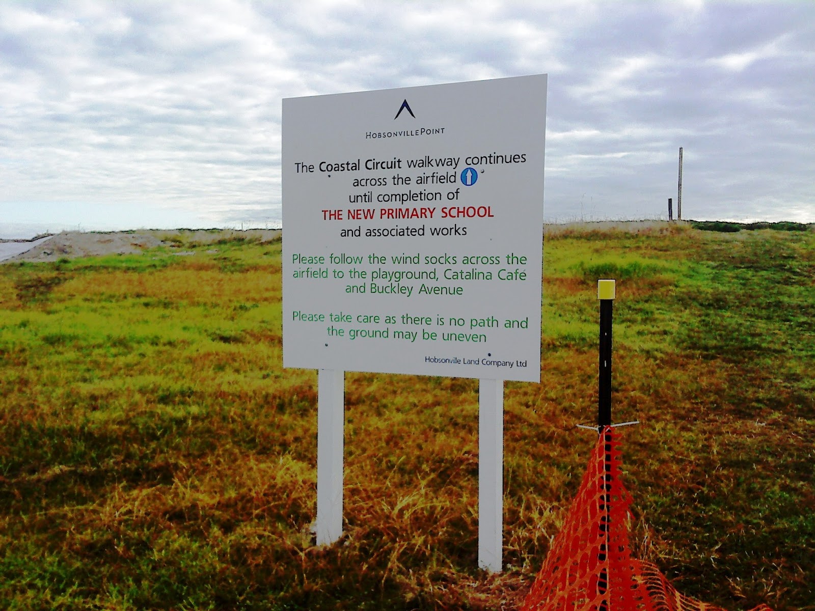
Eventually we came across signposts that lead us onto Bomb Point, it looked like there was a path in the grass and another walk.  We didn’t venture down the path but continued to the airfield where a sign told us to look out for the wind socks. Well with no wind socks in view we picked our way across the building site and walked across to where the new primary school would eventually be built.

Sign for Bomb Point which wasn't half as exciting as we expected
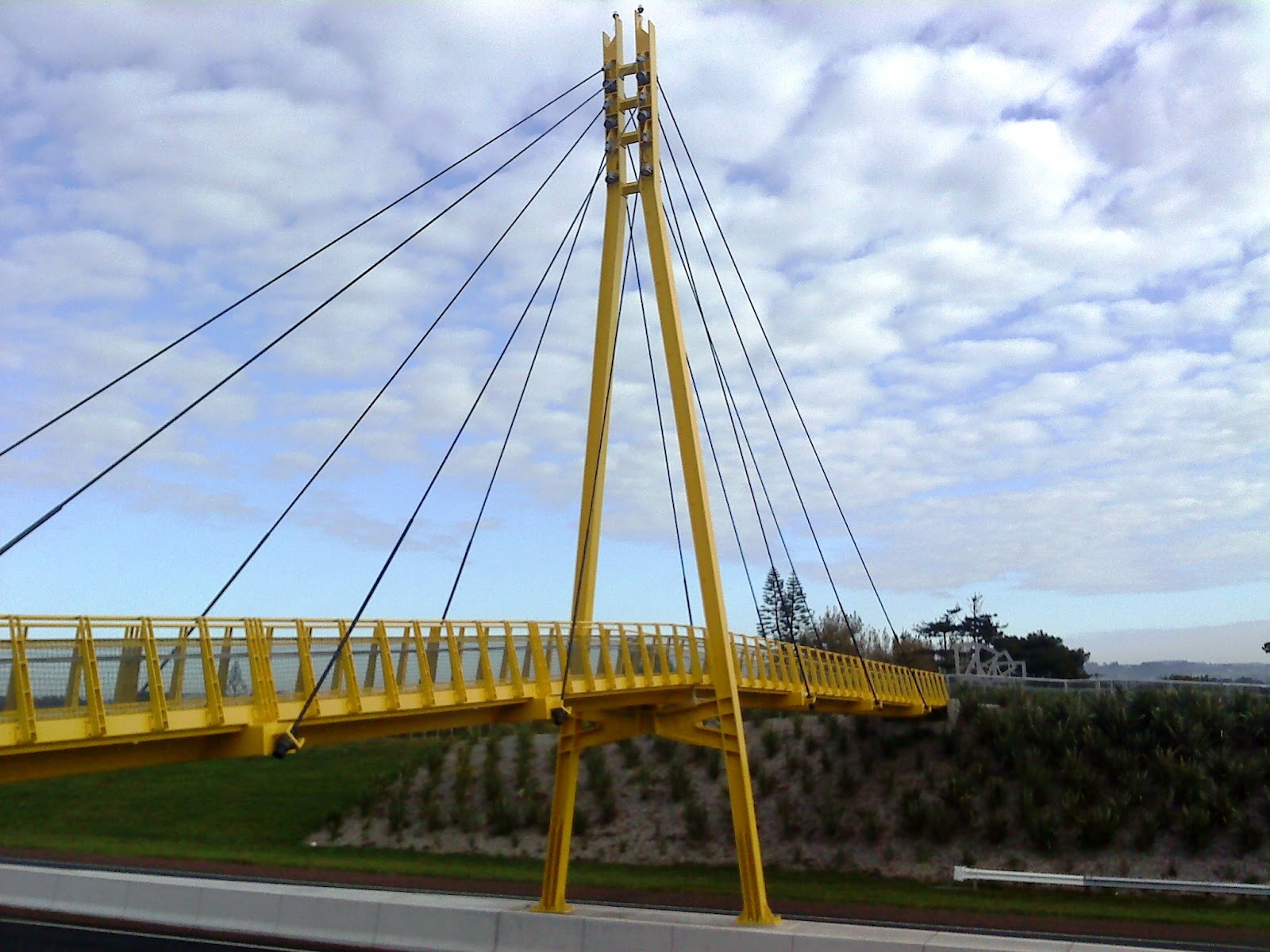
It was at this point when we came across a couple of ladies we saw earlier on the car park outside the Catalina cafe. I asked about any further walks and they pointed us in the direction of the yellow bridge so away we tramped, passing a pump station that we thought at first was a small church. We crossed over the road and made our way across the Memorial Park and onto Clarks Lane Footbridge.

Not a single windsock in sight!
The bridge is indeed canary yellow and is tiled at the edges with beautiful details, each tile along the end had some cycle or truck tread artwork being the creation of Matt and Kate McLean. They have been put together most decoratively and add a lovely touch to what could have been a boring path across a very busy highway.

From the bridge you can see what would have been some of the homes used by the pilots whilst working at Whenuapai airfield.  Mary pointed out some of the traditional houses and from where we stood we could also take a good view of the Sinton Windows Sculpture which was apparently created using recovered materials.
Clark Lane Footbridge
We were now ready for a coffee so we headed back past the park towards the cafe, however as usual we were distracted by the new housing development and took a slight detour to have a nosey at the new homes. 
Once satisfied that we weren't missing anything we ventured back past a lovely kiddies playground and onto the Catalina Cafe.

Matt and Kate McLean Tiles
The cafe was doing a roaring trade with hungry shoppers and walkers, however the queuing was short and service was fast, and I had two poached eggs on toast with lemon and ginger tea!  Some of the group went off to see the farmers market and the remainder made our way back to the car park.

Sinton Windows Sculpture
I think we’ll be returning to Hobsonville as it’ll be interesting to see the finished result - I might even go back and explore some of the other paths.

Information and Sources:
http://www.arc.govt.nz/albany/fms/main/Documents/Council/Consents/Notified%20applications/HobsonvilleLandco/Appendix%2010-21/Appendix%2010%20-%20Archaeological%20Assessment.pdf


Wednesday, 7 March 2012

Cure For Kids - Long Bay Beach

North Shore Nordic Walkers met locally on Sunday, only a few of us actually turned up, I suspect the weather bomb the previous day had put a lot of people off from walking, but as it turned out the morning was spectacular, it was slightly cold but lovely to walk in.

We met at Toroa Street, and parked outside Toroa Physiotherapy, we were joined by a Swedish gentlemen called Nils, I hope that’s correct, who brought along his poles and he told me that there is a path outside his home in Sweden that he walks most days.  He is visiting his son and family in Torbay and enjoying the company of his grandchild.
We walked down Toroa Street turning left at the bottom into Cliff Road and followed the track through the back of MERC and across the bridge to Long Bay beach.

Boat at Long Bay Beach
As we chatted and walked we noticed a boat in the water, it’s not often you see a boat at Long Bay and there appeared to be a couple of buoys in the water and another small orange craft bobbing around not too far from the markers.  It was as got closer we saw a camera crew and huge crowd of people gathered at the far end of Long Bay beach.

Crowd waiting for the Swimming Race
One of our walkers Pam E approached a chap in a wet suit to ask what was going on, and he explained that there was a triathlon event, a swim, run and bike ride through Long Bay.  It was then we spotted the Cure for Kids banners and then at this point swimmers set off down the beach and into the water.

Cure for Kids
We made our way across the beach onto the grass area and in the background near the back of the park were marquees and a finish line complete with bikes stood up and ready to be collected by the participants.  We stopped and chatted to a couple of the girls with laptops, who told us a little more about the event.  We carried on up the road towards the start of the Coastal Track but there were markers already in place for the bikes.  We decided to walk up to Vaughan Homestead so that Nils could take a look at the old traditional Kiwi weatherboard house that is currently run by volunteers and I believe it is to be opened for Devonshire teas shortly; now that would be a nice end to a morning walk!

Marker at the Coastal Track
Coming back we thought that we might pick up the Nature trail but a Marshall appeared and told us that the track was going to be used by the 12k runners so we headed back to the road.  We stopped at the Coastal Track entrance and spoke to another Marshall who was directing the bikes through, I mentioned that we had never seen the event at Long Bay before and apparently this is the first time the triathlon had been held at Long Bay.

Vaughan Homestead
We made our way along the footpath in single file to avoid any collisions with the bike race and came across someone trying to get an oven ready for the finish and the famished participants, the smell was divine.  We were bewildered as to what the oven was for and it apparently was for pizza!

We continued on along the road through the park and onto Beach Road, doing a bit of traffic direction as we passed through for people looking for the event.  We had to cross over to the opposite side of the footpath to avoid the orange traffic cones and the roadwork, climbing the hill to Torbay shops and then crossing over and back to Toroa Street.
It was a quick and short walk on Sunday but we did extend our time slightly by enjoying a coffee at the Baker’s Gallery.

Thursday, 23 February 2012

The Lucas Creek Walkway

A few of the North Shore Nordic Walkers met at Kell Drive on Sunday to explore Kell Park once again.  It was pretty cold in the morning and the mist was still hanging in the air and the grass was very wet!
Kell park, Albany

One of our regular walkers Pam E passed some walking books to me a few weeks ago, one of which was Explore the Shore, Volume One, Albany& Greenhithe Area Walks.  The booklets are available online or you can collect them from the library and information centres.

Cannon at the top of the Walkway overlooking the creek
The books have been put together by a lady called Margaret Scrymygeour, they are beautifully illustrated with maps and written instructions on local walks.
I have met Margaret at one of the Walk to Work events in Takapuna in 2010 organised by Living Streets Aotearoa and Auckland City Council.  Margaret is a lovely lady with heaps of local knowledge and she put the maps together a while ago; I've used The Harbour Sports website to print her maps, its lovely to see them all professionally published and presented in these wonderful booklets.
As we had already been to Kell Park and wandered about there the previous week I decided that we should try the Kell Park and Lucas Creek Track and take the 5 km walk that features in the booklet.
The painted chooks and some of our Nordic Walkers

We met at the car park which is located in Kell Drive behind the shops and library at Albany.  This is a recently developed suburban area with lots of lovely houses which run adjacent to one of the local and oldest waterways.
Following the instructions we followed the path down to the Creek and took the left hand walkway across the footbridge, walking along the concrete footpath and turned right across the grass into the Nature Reserve. We walked across with wet trainers until we reached Wharf Road and at the signpost for the Reserve we went straight over Wharf Road and continued along the grass, and crossed over onto the Lucas Creek Walkway.

The huge slide at Kell Park
At Kinleith Way there is an exit into a walkway between a couple of houses and crossing the road,  we encountered another walkway which exited at Mahoney Drive, which passed through a third walkway further along Mahoney Drive and exited into Vinewood Drive. 

Following our map we continued and took a right at the playground into Roanoak Way taking yet another walkway between the houses and that’s where it all became very confusing.

Beautiful carved wooden chair in the park
Alan had joined us for our walk this week, Alan usually walks with the group in Northcote but has brought his poles along to walk with us before.  Alan and I agreed that at this point the instructions were a bit confusing so we took a right and followed the path back and eventually made our way to Wharf Road and onto The Landing. What we should have done really was go back across the wet grass to Wharf Road. From The Landing we took a right into Landing Drive and at Widdison Way we crossed over to the walkway and then made our way back to the Nature Reserve.

The Albany Village Logo
We followed the footpath back to Kell Park and back up to the platform where we had earlier met a few of the local dog owners, one of which had tried Nordic Walking at Long Bay in the past. I love the cannon here and there's a huge slide as I mentioned last week and down the steps to the left is the flying fox. We could see eels swimming in the creek below.

At the end of the walk we had the opportunity to stroll around the fruit trees by the children's playground and had a debate over some of the fruit and  what we thought was a pear tree is actually a quince.  There are also some wonderful wooden sculptures in this area, one of which is an enourmous wooden chair beautifully carved from a tree trunk.

After talking for a while we made our way back to the cars and had a coffee at the Opium Cafe, however being so early  on a Sunday we had to take a stroll for 10 minutes while they opened. Despite the dubious name the cafe serves excellent blueberry muffins!

The Chooks
It’s worth noting that there will be Art in the Park next weekend at Kell Park, and if you’re free take the kids or grand children, it’s a great venue and there are some intersting sculptures dotted around.

Make sure you look out for the beautiful painted chooks on the wall.

Wednesday, 15 February 2012

The Coastal Track - Long Bay

Despite the cloudy start on Sunday we managed to get a two hour walk in at our favourite and local beach Long Bay.  Only a few of the North Shore Nordic Walkers walked this Sunday as a number of walkers were away or were otherwise busy.  The weather in Auckland is exceptionally humid at the moment and I personally have found it difficult to walk in, it can affect breathing and makes walking exceptionally hard work.  The temperature has been around 24- 26 but feels much hotter, even the brief showers that we’ve been having are not bringing that much relief.

Some of North Shore NordicWalkers,  Long Bay Coastal Track

We met and walked down Toroa Street in Torbay, turned left into Cliff Road and down to the bottom of the road; from there we made our way to the Oneroa track and down to Long Bay Beach.  We passed MERC (Marine Education Recreation Centre) on the right and made our way across the foot bridge and turned left to follow the road right into the park.

After the short walk up to the bottom car park we followed the sign for the Coastal Track on the right, which took us up and onto the cliff.  The walk is hard work as there is a slight incline all the way to the top but what makes it harder is that underfoot the path is gravel; hard for poles to gain purchase and certainly unkind to knees should one take a tumble.  The other setbacks along the route are cattle grids and gates, it does seem that you are forever opening and closing gates and as we all know cattle grids aren’t particularly great for navigating whilst holding onto poles, what with that and the added hazard of stepping into cow pats makes the walk a little challenging.

Rangitoto from the Cliff top, Long Bay
Once at the top of the cliff the views are spectacular overlooking the Hauraki Gulf and even though the weather wasn’t clear we could make out a number of the small islands surrounding the Shore.  We made our way down to Granny’s Bay which is a small beach and at Low tide it is possible to walk across and back to Long Bay. It’s not always advisable though as you have to scramble across rocks and if they are still wet it can be dangerous underfoot, also like many of the cliffs in the area they are unstable and it isn’t advisable to walk so close to the cliff.

Granny's Bay, Long Bay

Granny's Bay Beach
We admired the view from Granny’s Bay and some of our locals did attempt to name some of the islands in the distance but I had to look them up when I came home, as no one seemed 100% certain although Rangitoto was of course instantly recognisable.  On the right of Rangitoto there is Motutapu which is now a reserve and a lot older than Rangitoto and it also has a very different botanical and geological environment than Rangi (as it’s known locally). I was told by the ladies of the group that there is a causeway between Rangi and Motutapu and there are walking tracks to explore there (watch this space as I feel a ferry ride coming on).  On a clear day we can see all the way over to the Coromandel peninsula and I suspect Great Barrier Island. Out to the east of Gulf Harbour, not far from Shakespear Park and across the water is Tiritiri Matangi.
Tiritiri Maitantgi - Photo 2010
Tiritiri Matangi or Tiri is an open sanctuary and reserve which I have visited in the past and it’s a fabulous place having undergone an extensive replanting programme run by many volunteers and is now home to many endangered NZ animals and birds, including the famous Greg a naughty Takahe. Greg is partial to the odd sandwich, in fact when we were there he managed to swipe a chicken sandwich from an unsuspecting child, we weren’t sure if this made him a cannibal!  They are quite a large ungainly bird very similar in colouring to the smaller Pukeko although the experts would probably tell me otherwise. There only a couple of hundred left of these birds, they are wonderful to watch and with all the beautiful birds on Tiri Island it does make trip by ferry worthwhile. Again another potential walking day but are walking poles allowed?
Greg, Tiritiri Mataingi - 2010

After our brief stop at Granny’s Bay we walked back the same way but on the return trip we picked up the Nature Trail on the left at the bottom of the Coastal Track which took us back down the cliff onto wooden steps and into bush. The trail here is relatively short and mainly boardwalk covered with a kind of mesh to prevent slips although it’s a bit of a nuisance for poles and you do have to be careful that you don’t lose an asphalt paw on the way around.  This trail brought us out by the side of Vaughan Estate and turned right back into the park over the bridge where we stopped a while to watch the eels.  Making our way back via the road we took a shortcut across the park and headed down to the beach.
The beach was very busy with lots of dogs, but the weather was starting to change so we quickly ducked back over the small bridge opposite MERC and headed up Beach Road and back to Toroa Street, we did get slightly damp but after a two hour hike over the cliff we were very keen to have our coffee at the Artisans Bakery at Torbay shops.
Sadly there were no date scones left, but I can happily report that the blueberry muffin was exceedingly good!
Information & Sources:

Greg, YouTube and the Tiri Takahe experience http://bit.ly/x5aYVr